This system uses a handheld high-precision GPS measuring terminal to measure the blasting range and upload it to the server via wireless network; On the host computer, according to the range of the uploaded blasting area, automatic hole layout is designed and the blasting hole distribution is designed, the hole positions after the layout will be downloaded to Drilling rig terminal; Apply the high-precision GPS positioning system to the drilling rig to automatically guide the drilling rig. After the drilling task is completed, the drilling completion status is automatically uploaded to the server, the system automatically checks whether the drilling task meets the standard, eliminating a series of the cumbersome work, avoids the situation such as the execution of the work is not in place, improves the automation level of the mining, improves the production and operation efficiency.
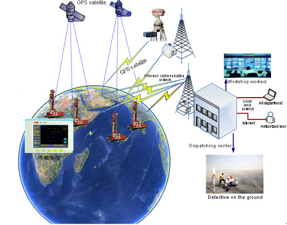
Rig system architecture
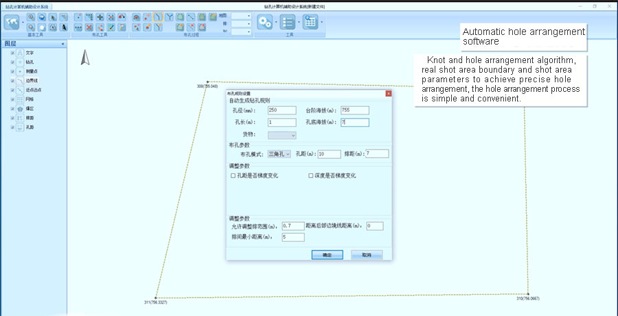
1.The automatic hole arrangement saves time and effort compared with the traditional hole arrangement method, guarantees the hole network parameters and does not arrange the wrong hole;
2.Automatic hole arrangement by technicians is more free, convenient and quicker than the previous arrangement method;
3.High-precision automatic hole alignment is faster and more convenient than traditional hole alignment methods, which greatly improves the speed and efficiency of drilling rigs;
4.High-precision automatic hole alignment greatly improves the accuracy of hole alignment compared with the traditional method of hole alignment, which can be guaranteed to be 10cm~15cm;
5.The high-precision automatic hole alignment greatly improves the drilling efficiency compared with the traditional hole alignment method, the workload of each shift can be increased by 5%;
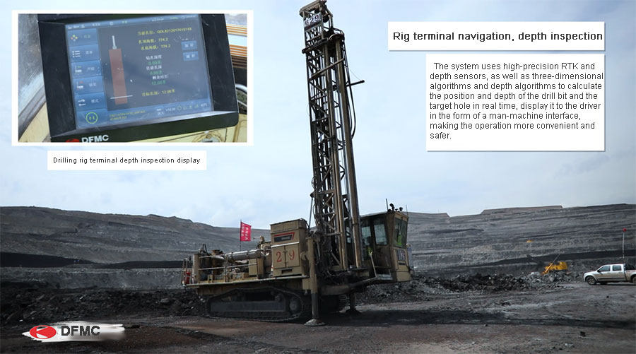
6.The accuracy of the automatic detection of the drilling depth is up to +10cm,the drill bit elevation is provided to ensure the blasting effect and save blasting materials.
1.The horizontal accuracy of the drilling is 20 cm and the vertical accuracy is 20 cm (including the operator's operating error).
2.It can record the altitude, depth, location, drilling time, etc. of the borehole.
3.The deviation between the actual drilling position and the design position can be clearly displayed.
4.The coordinate system adopts the custom coordinate system of the mining area, the system can automatically realize the coordinate conversion.
5.Multiple hole design drawings can be downloaded to the machine, the driver can switch between different design drawings for work.
6.The system provides real-time data to the driver through the LCD screen, the driver adjusts operations based on the feedback data.
7.Monitor and record the production process data of the drilling rig for easy analysis afterwards.
8.Data information is transmitted to the dispatch center for analysis, reporting and decision-making.